People claim that the section of the PCT from Harts Meadows to Rainy Pass is one of the prettiest, so we left a truck at Rainy Pass, and had friends take us to the trail head at Hart Meadows. The road to the trail head is narrow in places, but improved, according to our driver. We originally had planned to start at the pass, but impending rain convinced us to cut off a couple of miles and start at the meadows.

The hike began with a bit of a march up the shoulder and around Tatie Mountain. For me the steady work up four hundred feet of elevation felt more like a thousand under the weight of my first big backpack trip of the summer. The shoulders and back were feeling the pressure of my future comfort and over-preparation, even as a twenty-something PCTer ran by me with a pack half the weight.
The trail starts with broken rock and sand and climbs at a fair grade skirting the edge of an old forest fire. The basin is tamarack and spruce. Wildflowers are in full bloom. After the saddle below Tatie, the trail holds most of its elevation for nearly five miles as it turns more directly south towards Glacier Pass. On the way, we saw brief, stunning views of Mt. Ballard and later, Azurite Peak during breaks in the clouds.

We wanted to start off easy, and looked for an early camping site. However, the more exposed spots at Glacier Pass looked less inviting to us in the presence of threatening weather. We soldiered on down 1,200 feet towards Brush Creek where we were hit with solid rain. Bush Creek looked hospitable enough of a camp, but, hey it was only 3:30 PM, and we asked each other, “Who wants to sit around camp, doing nothing when the sun wouldn’t be setting until after 9?” If we had stayed at Bush Creek we would had a much more enjoyable evening. In our ignorance, we continued down the trail.

From the woody, Bush Creek camp, we hiked into a solid rain on the worst part of the trail. Trailcrews hadn’t cleared the section this season, and in a number of places the vegetation completely hides the trail. If the rain doesn’t soak you, the salmonberry and Solomon’s seal along the way certainly will. A few blown down trees were mixed in to make the little 2 1/2 miles journey unnecessarily hellish. Luckily, it was a warm rain. We opted only to cover our packs and not pull on rain gear for the short distance. Our cores stayed warm from the work, but our boots were drench. It was a stupid day not to wear gators.

The Methow Trail Camp was a welcomed site. We were able to find decent spots to put up our tents among the tree before the onslaught of PCTers came crashing in. At least ten arrived after us. I felt sorry for the ones eating granola bars or a gel for dinner before crawling into pup tent without walls or a floor in the rain. The forty pounds of comfort I was carrying felt worth it that night. The trip so far was mostly down hill. The next day would cover half the miles but climb from 4300 to 6500 feet over 8.4 miles.

Making our way up to Methow Pass, we started in the forest that was humid after the rain. We lounged around until ten before leaving camp. The PCTers were all long gone by then. The first part of the day was nice, but the 1000 foot ascent after crossing the treeline is some work concentrated in a short distance. The view from Methow Pass was sublime, and we dropped down to camp below Snowy Lakes.

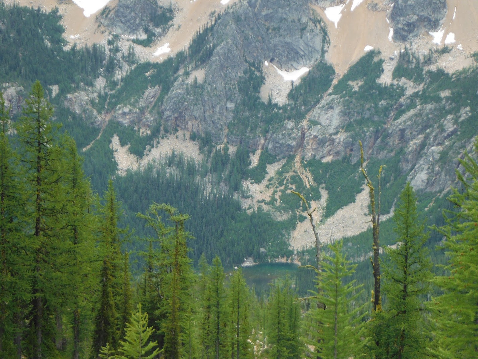
On Thursday night we were the only ones at the lower camp. A couple tented up a few windy nights at Lower Snow Lake, but we preferred the shelter of the saddle below. Some mosquitoes proved to be only a small irritation. The evening was pleasant, and while it started out windy, the night ended still and cold. We woke up to a little bit of frost. I climbed the steep, rough trail to Lower Snow Lake and was treated to the beauty of Golden Horn Mountain reflected in still waters of the lake.

On Friday, we headed towards Granite Pass along a trail cut into the edge of the ridge. In a few slide spots, you need to be attentive. The steep talus slope looks pretty unforgiving. The switchbacks above Granite Mountain acquire several hundred feet in a hurry, and I felt the work. Before connecting with the ridge trail to Cutthroat Pass is a small but steep snow field. We used trekking poles without traction and felt comfortable. Earlier in the season, or in a snowier year, an ice axe and microspikes would be worth the added weight.
As we turned towards Cutthroat Pass, the PCT hikers were replaced with overnighters and day hikers. Some came up from the Cutthroat Lake trailhead while others worked their way from Rainy Pass. We thought we would see what campsites were available at Cutthroat Pass. Really, the only one with a great view and good water was already taken by 1 PM. We had a nice chat with some Canadian hikers who were only a couple of comfortable hours out of Rainy Pass, we elected to head out for a burger and beer in Marblemount.
No comments:
Post a Comment