Tuesday, July 22, 2014

The Oyster Dome: An All Seasons Hike


The Chuckanut Mountains are an ancient upwelling that shore up the Salish Sea just south of Bellingham. Washington.  Ancient and worn down, they predate their upstart and angry Cascade neighbors to the east by eons.  In the last ice age, some of the higher peaks of the Cascades asserted their prominence beyond the frozen sheet.  Alas, the Chuckanut Mountains slumbered beneath the deep and heavy winter.  Fortunately, for us modern folks, the ice receded and left us a few glacial polished high points worth a half day adventure anytime of year.  The Oyster Dome, on Blanchard Mountain,  is the most popular. At 2025 feet, the outcropping above the beach offers a unique vista from the San Juan Islands to Canada.  You can mark the slow progress of ships at sea while snacking on trailmix.  On our last trip up, two bald eagles put on an aerial display swooping and tumbling in the updrafts.

Close to the outdoorsy college town of Bellingham, the Oyster Dome trailhead is problematic. Year round, a lot of folks are eager to head up.  Unfortunately, there is no parking lot available on this side of the hill.  Cars must park on the shoulder of Chuckanut Drive, and it's been reported that  vehicles over the fog line have been towed.  The near-by Oyster Bar Restaurant is also off-limits, even for early morning trekkers.  The trails are on state lands, so a Discovery Pass is required.  However, a final, uncomfortable reality is the lack of a toilet.  Take care if you venture off trail to relieve yourself--the hill is steep.

Start early and you'll have a more pleasant start to the hike.  The first part of the trail is well maintain if a bit aggressive.  After all, the way ascends from a few hundred feet above the Salish Sea to just over 2,000 in a rapid three or so miles.  A few trail crossing can also be confusing. The Oysterdome Trail intersects with the Pacific Northwest Trail twice.  In each instance stay left as you make your way through a lowland forest of fir and hemlock.

The bat caves at the base of the rocks are closed now for fear of spreading white nose syndrome among the native bat species.  By June, the turn off sign had been removed.  After the old turn off point, the trail is ridiculously steep--really a scramble up 200 yards of roots and rocks.  Here, all hikers can benefit from trekking poles, on the way up, and especially on the descent.   At the top of the scramble, take the second left, across the creek, and you are a quarter mile from the through thin but dense second growth  to the top.  The other way leads to Lily Lake.

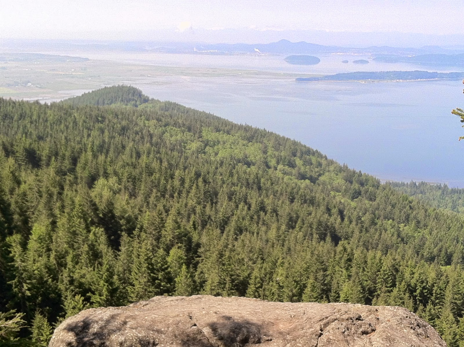
The Dome is a bit of a misnomer.  This is not an orb sculpted from granite, but rather a edge of a folded crust.  Still, it offers a stunning view of the Puget Sound.   Take care along the edge.  The exposure is real enough, 300 feet to the foot of the bat caves.  Thousands of  panoramics and selfies are snapped at the Oysterdome every year.  Don't be distracted by the view.

Even when its not a perfect day in July, the 1900 foot accent is worth the effort.  When we were there in late winter, the elevation was enough to put us in snow while the lowlands endured drizzle.  The snowfall has its own beauty but it obscures the point of the hike; we made our way down fairly quickly after the flurry began.

Our last trip in June, we made the side trip to Lily Lake where we enjoyed the wild irises among the pond lilies.  The work of beavers is evident everywhere making the short excursion a fun destination for kids. Fall spruce giants provide piers almost to the middle of the boggy lake.  A few minnows scattered from our shadows while dragonflies patrolled the above the water.

For the ambitious, other trails can lead to the other side of the mountain, Lost Lake Fragrance Lake, and even Lake Samish, but that would turn a half day adventure into a full one.

From Seattle, getting to the Oysterdome Trailhead is simple.  Head north 75 miles on I-5 for an hour and 15 minutes or so, then take Exit 231 to Chuckanut Drive (Hwy 11 north) on the west side of the freeway.  The trailhead is just past mile post 10 on the uphill (east) side of the road.  Be careful making the u-turn to face your car in the right direction--motorcyclist and BWM drivers love to ride the curvy road fast, and make sure you are completely off the road, so you don't end a great hike searching in vain for a towed  vehicle.


Tuesday, July 1, 2014

Beckler Peak's Fantastic Vistas


  The Forest Service Road (6066) to the Beckler Peak trailhead is rutted and rugged.  Chunks of granite brought in by the Forest Service to patch the holes sometimes rudely announced their resistance to traffic by thumping against the underside of the sedan I was riding in.  Clearance is everything on this road.  It's over six miles of single lane, slow going from Hwy 2 to the start of the trail. With reports of late winter blow downs blocking the road (though cleared some weeks earlier) and heavy snow on the trail (perhaps a bit overstated), the parking lot was almost empty--one other car when we arrived on the last morning of June.   Apparently, solitude here should be cherished--the new trail to Beckler Peak was only opened a few years ago, but the word has gotten out that the vistas are well worth the effort.


The trail to the summit is a bit more than 3 1/2 miles.  It begins on a converted longing road, at the edge of "working forest," but the cool shadow of hemlock disguise the fact well.  Lupine and tiger lilies adorn the trail.  When we were on the trail, the fireweed was a week or two from blooming into profusion.  The way up the first part is un-apologetically steep. Our minds were distracted by discussions of botany and potential herbal remedies, but our calves were not.  The ascent can get your heart pumping to a beat your feet can't keep pace with.  Fortunately, the road relinquishes the way to a carpet-like trail that sashays towards the west and ridge where the Beckler finally made his point at 5062 feet.

We encountered patches of snow, four feet deep in places, but trail was well trampled.  Like many middle-aged hikers, I am a convert to trekking poles.  On snow, they help you keep your footing and spread the load a bit.  If you should post hole down, poles can keep you from twisting a knee or breaking an ankle.  They also help you burn a few more calories as your arms become more involved in your life.  For me the biggest pay off is the stress they take off the knees especially on the down hill.


Once you're in the second growth forest below the summit, the incline has been nicely mitigated by a few strategic switchbacks.  Well placed rock steps keep the trail from spreading into a quagmire during the melt out.  After nearly two hours of work, summit came suddenly.  It seemed as if we were in the rocks and spruce one moment, and in the next, on top of the world. Leonardo diCaprio, however, was no where to be seen.  Mind your step when you reach the top.  Between you and Glacier Peak to the north is a unbridgeable chasm.  The views here are 180° of peaks,  valleys and the little of town of Skykomish clinging to its namesake river.

Beckler Peak compares favorably to other vista hikes in the Central Cascades.  It is a little stepper and longer than Mt. Pilchuck, but the trail is nicer, and there are far fewer people on a weekday.  On Beckler, we met a retired couple coming down the hill.  After spending a hour or so on top, we headed down, and met a couple of college kids heading up.  A half day on the trail, and we encountered a total of four people.   Compared to last week's hike on Pilchuck, on a misty day, when we crossed paths with scores of other hikers, this was solitude.

Mt. Pilchuck is a favorite hike of mine.  Coming from Snohomish, it's easy to get to.  It also has an historic lookout and plenty of room for everyone at the summit.  Beckler, on the other hand, has no look out, and only room for six or eight hikers on top.  That being said, the view from Beckler is unrivaled. It is definitely worth the effort.

To get to the Beckler Peak Trailhead, take Hwy 2 East (about an hour out of Everett).  Approximately, two miles past the Skykomish Ranger Station, you'll see the sign for FR 6066 on the left.  It is an abrupt turn off the highway, so use caution.  Stay right at the Y 1.8 miles up the road, and head up hill.  The trailhead is just under 4 miles of rough road away.  Unless you are in a Range Rover, it will take at least a half-an-hour of dodging and weaving potholes and rocks to get there.  On the day we were there, much to the irritation of the ladies,  the privy was inexplicably locked the entire time


.