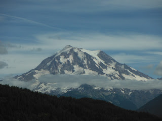
My twenty-something son, Dave, and I wanted to find a hike that my 12 year old nephews would find fun and rewarding without feeling like a death march. On paper, Tolmie Peak looks like it fits the bill. With only 1,100 feet of climbing over 3.75 miles, the trail offers enough work to make feel you have accomplished something without creating an aversion to hiking among the youth of America. In addition, the two lakes, the historic lookout, and the in-your-face beauty of the mountain offer a big payoff for your effort.
 |
| On Federal Lands. The Carbon River Entrance. |
The second concern is trail access. Mowich Lake Road access also earns a lot of loud raspberries in guide books and in the WTA trail reports for its gut twisting bumps and potholes. It is not the worst mountain road I've been on this year, but it does have some serious wash boarding. We were happy to be cruising in our Highlander. The road also provides access to the Evans Creek Offroad area, so you can count on some speeding four-wheelers kicking up dust as they roar by.
After our jarring ride up the washboard, we parked along the road, and headed down to the trail along Mowich Lake around 10:40 AM. The trails were busier than we expected for a mild and misty Thursday morning. Mowich is a big lake (118 acres) with a campground (permit required) but apparently, lousy fishing. Had it been warmer, we were planning to jump inat the end of our hike. Instead, we appreciated the cool hiking conditions as we climbed the saddle between Mowich and Lake Eunice.
At the Ipsut Pass junction, stay left. This marks the high point of Mowich ridge. The few hundred feet you have gained climbing the ridge drop away along some switchbacks. You'll have to climb back through roots and rocks, plus another 400 feet to reach Eunice where she presses up against Tolmie. The elevation totals are understated. The hike will feel more challenging than its listed distance and elevation gain.
 |
| Can you find the striped coralroot among the detritus of the forest? |
Western Hemlocks dominate the forest between the lakes. My nephews were telling me about sixth grade science and studying photosynthesis. I told them to look for striped coral roots that live in the decomposing fallen needles of the conifers. Coral roots have no chlorophyll, yet flower anyway in the half-light of the forest. It wasn't until our hike out that we found afew about where I expected.
Judd's guidebook describes a muddy mess of a trail regaining the ridge towards Eunice Lake. We didn't find this, though it has been a dry summer after a record rainy wet winter. Luke and Sam were the only young people hiking the trail, but we saw no tantrums or meltdown along the way. A large group of Senior women, denying they were from Renton, were keeping a steady pace along the way. One explained to that she didn't see the point of racing up the hill. "You miss so much," she told us. A trailrunner passed by almost on cue.
 |
| The misty top of the mountain |
Higher up, a few flowers were blooming, paintbrush and bluebells, but an abundance of ripe blue huckleberries tempted us along the way. A breeze kept the bugs away.
Coming into Eunice Lake cirque was sudden. Eunice is a gem of a sub-alpine lake fringed with sandy beaches. I imagine on a hot summer day the cold waters would bring some relief.
 |
| Eunice Lake from above edged in sandy beaches |
We snapped some photos, drank some water, and rested a bit before heading up to the top of Tolmie Peak, still half hidden in a gauzy fog cover. The last push to the lookout wasn't as bad as some guides make it out to be. It is a 600 foot climb in about a mile. My 12 year old nephews easily handled the climb, with only a couple of pauses along the way.
 |
| Regaining the elevation to Eunice Lake |
When we arrived at the top, it was windy and misty. We put on jackets and ate our lunch. We were a little disappointed the lookout was locked up. but the big windows offered a look into the austere past on the fire watch including a manual from 1957.
 |
| Plenty of Daylight in the lookout. |
 |
| A manual on fire, smoke and mist. |
 |
| Three friends from France tagged the next peak. |
God Bless the Renton Women's Auxiliary Hiking Club, but on that particular Thursday afternoon, it was going to be awhile before the sky cleared. It wasn't until were driving out of the park three hours later that the main act appeared on stage. Eunice was pretty, the ridges sublime, but the mountain remained invisible while we were on top of Tolmie Peak.


No comments:
Post a Comment