Tuesday, July 22, 2014

The Oyster Dome: An All Seasons Hike


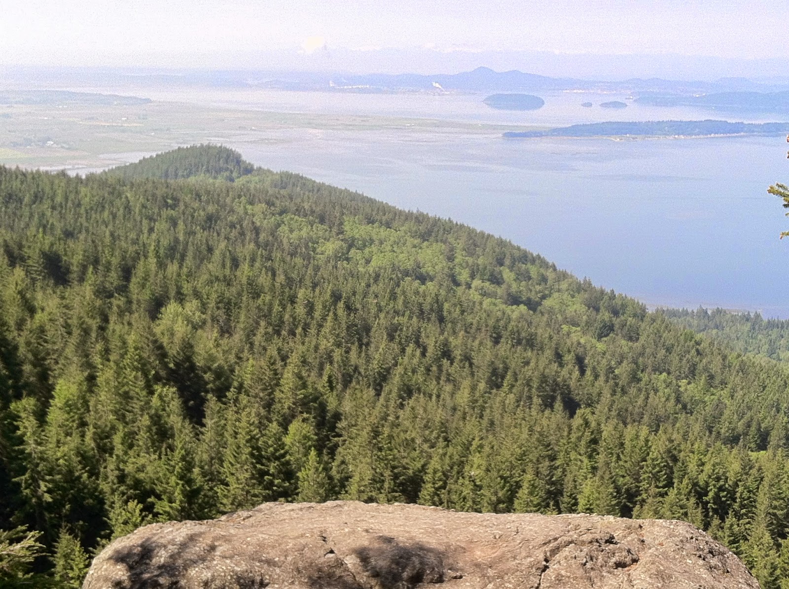
The Chuckanut Mountains are an ancient upwelling that shore up the Salish Sea just south of Bellingham. Washington.  Ancient and worn down, they predate their upstart and angry Cascade neighbors to the east by eons.  In the last ice age, some of the higher peaks of the Cascades asserted their prominence beyond the frozen sheet.  Alas, the Chuckanut Mountains slumbered beneath the deep and heavy winter.  Fortunately, for us modern folks, the ice receded and left us a few glacial polished high points worth a half day adventure anytime of year.  The Oyster Dome, on Blanchard Mountain,  is the most popular. At 2025 feet, the outcropping above the beach offers a unique vista from the San Juan Islands to Canada.  You can mark the slow progress of ships at sea while snacking on trailmix.  On our last trip up, two bald eagles put on an aerial display swooping and tumbling in the updrafts.

Close to the outdoorsy college town of Bellingham, the Oyster Dome trailhead is problematic. Year round, a lot of folks are eager to head up.  Unfortunately, there is no parking lot available on this side of the hill.  Cars must park on the shoulder of Chuckanut Drive, and it's been reported that  vehicles over the fog line have been towed.  The near-by Oyster Bar Restaurant is also off-limits, even for early morning trekkers.  The trails are on state lands, so a Discovery Pass is required.  However, a final, uncomfortable reality is the lack of a toilet.  Take care if you venture off trail to relieve yourself--the hill is steep.

Start early and you'll have a more pleasant start to the hike.  The first part of the trail is well maintain if a bit aggressive.  After all, the way ascends from a few hundred feet above the Salish Sea to just over 2,000 in a rapid three or so miles.  A few trail crossing can also be confusing. The Oysterdome Trail intersects with the Pacific Northwest Trail twice.  In each instance stay left as you make your way through a lowland forest of fir and hemlock.

The bat caves at the base of the rocks are closed now for fear of spreading white nose syndrome among the native bat species.  By June, the turn off sign had been removed.  After the old turn off point, the trail is ridiculously steep--really a scramble up 200 yards of roots and rocks.  Here, all hikers can benefit from trekking poles, on the way up, and especially on the descent.   At the top of the scramble, take the second left, across the creek, and you are a quarter mile from the through thin but dense second growth  to the top.  The other way leads to Lily Lake.

The Dome is a bit of a misnomer.  This is not an orb sculpted from granite, but rather a edge of a folded crust.  Still, it offers a stunning view of the Puget Sound.   Take care along the edge.  The exposure is real enough, 300 feet to the foot of the bat caves.  Thousands of  panoramics and selfies are snapped at the Oysterdome every year.  Don't be distracted by the view.

Even when its not a perfect day in July, the 1900 foot accent is worth the effort.  When we were there in late winter, the elevation was enough to put us in snow while the lowlands endured drizzle.  The snowfall has its own beauty but it obscures the point of the hike; we made our way down fairly quickly after the flurry began.

Our last trip in June, we made the side trip to Lily Lake where we enjoyed the wild irises among the pond lilies.  The work of beavers is evident everywhere making the short excursion a fun destination for kids. Fall spruce giants provide piers almost to the middle of the boggy lake.  A few minnows scattered from our shadows while dragonflies patrolled the above the water.

For the ambitious, other trails can lead to the other side of the mountain, Lost Lake Fragrance Lake, and even Lake Samish, but that would turn a half day adventure into a full one.

From Seattle, getting to the Oysterdome Trailhead is simple.  Head north 75 miles on I-5 for an hour and 15 minutes or so, then take Exit 231 to Chuckanut Drive (Hwy 11 north) on the west side of the freeway.  The trailhead is just past mile post 10 on the uphill (east) side of the road.  Be careful making the u-turn to face your car in the right direction--motorcyclist and BWM drivers love to ride the curvy road fast, and make sure you are completely off the road, so you don't end a great hike searching in vain for a towed  vehicle.


Tuesday, July 1, 2014

Beckler Peak's Fantastic Vistas


  The Forest Service Road (6066) to the Beckler Peak trailhead is rutted and rugged.  Chunks of granite brought in by the Forest Service to patch the holes sometimes rudely announced their resistance to traffic by thumping against the underside of the sedan I was riding in.  Clearance is everything on this road.  It's over six miles of single lane, slow going from Hwy 2 to the start of the trail. With reports of late winter blow downs blocking the road (though cleared some weeks earlier) and heavy snow on the trail (perhaps a bit overstated), the parking lot was almost empty--one other car when we arrived on the last morning of June.   Apparently, solitude here should be cherished--the new trail to Beckler Peak was only opened a few years ago, but the word has gotten out that the vistas are well worth the effort.


The trail to the summit is a bit more than 3 1/2 miles.  It begins on a converted longing road, at the edge of "working forest," but the cool shadow of hemlock disguise the fact well.  Lupine and tiger lilies adorn the trail.  When we were on the trail, the fireweed was a week or two from blooming into profusion.  The way up the first part is un-apologetically steep. Our minds were distracted by discussions of botany and potential herbal remedies, but our calves were not.  The ascent can get your heart pumping to a beat your feet can't keep pace with.  Fortunately, the road relinquishes the way to a carpet-like trail that sashays towards the west and ridge where the Beckler finally made his point at 5062 feet.

We encountered patches of snow, four feet deep in places, but trail was well trampled.  Like many middle-aged hikers, I am a convert to trekking poles.  On snow, they help you keep your footing and spread the load a bit.  If you should post hole down, poles can keep you from twisting a knee or breaking an ankle.  They also help you burn a few more calories as your arms become more involved in your life.  For me the biggest pay off is the stress they take off the knees especially on the down hill.


Once you're in the second growth forest below the summit, the incline has been nicely mitigated by a few strategic switchbacks.  Well placed rock steps keep the trail from spreading into a quagmire during the melt out.  After nearly two hours of work, summit came suddenly.  It seemed as if we were in the rocks and spruce one moment, and in the next, on top of the world. Leonardo diCaprio, however, was no where to be seen.  Mind your step when you reach the top.  Between you and Glacier Peak to the north is a unbridgeable chasm.  The views here are 180° of peaks,  valleys and the little of town of Skykomish clinging to its namesake river.

Beckler Peak compares favorably to other vista hikes in the Central Cascades.  It is a little stepper and longer than Mt. Pilchuck, but the trail is nicer, and there are far fewer people on a weekday.  On Beckler, we met a retired couple coming down the hill.  After spending a hour or so on top, we headed down, and met a couple of college kids heading up.  A half day on the trail, and we encountered a total of four people.   Compared to last week's hike on Pilchuck, on a misty day, when we crossed paths with scores of other hikers, this was solitude.

Mt. Pilchuck is a favorite hike of mine.  Coming from Snohomish, it's easy to get to.  It also has an historic lookout and plenty of room for everyone at the summit.  Beckler, on the other hand, has no look out, and only room for six or eight hikers on top.  That being said, the view from Beckler is unrivaled. It is definitely worth the effort.

To get to the Beckler Peak Trailhead, take Hwy 2 East (about an hour out of Everett).  Approximately, two miles past the Skykomish Ranger Station, you'll see the sign for FR 6066 on the left.  It is an abrupt turn off the highway, so use caution.  Stay right at the Y 1.8 miles up the road, and head up hill.  The trailhead is just under 4 miles of rough road away.  Unless you are in a Range Rover, it will take at least a half-an-hour of dodging and weaving potholes and rocks to get there.  On the day we were there, much to the irritation of the ladies,  the privy was inexplicably locked the entire time


.


Wednesday, February 26, 2014

Cherry Creek Falls: Pretty and Easy


Cherry Creek Falls is a mellow, lowland hike of five-mile (round trip) that is lovely in summer and accessible in the winter when heavy snows close most mountain trails to all but intrepid snowshoers and backcountry skiers.

Recently, we hiked the old logging road that has devolved into a ruburban trail to Cherry Creek Falls. Along the way, we passed the wreckage of rowdier times when the sons and daughters of dairy farmers and loggers went joyriding on back roads.

 I can imagine how on a rainy day the trail might become (in the words of ee cummings) mudluscious.  On the day we walked the path, it was half frozen by a week of cold weather.  The route is flat, but in certain times of the year, a branch of Cherry Creek rises high enough to require a bit of log balancing and rock hopping to cross.

 The trial to the falls forks to the right after fording the creek, but there is no sign posted, so it's easy to miss.  Turn right past the creek.  After a few hundred yards of descent, the trail will first bring you by the crest of the falls.  When we visited, the rush of water was impressive.

A deadfall allows passage across the top for a view of the maelstrom crashing into the pool below.  Best not to cross.  It's slippery on a good day.  In the rain, a broken neck is almost guaranteed.  If you must have a look, you'll realize that you are not at Snoqualmie Falls, but the scene is pretty enough and probably sufficiently treacherous to nearly qualify as sublime.

Recrossing the the log, and a quick jaunt to the left brings you to a small meadow and cool waters at the base of the falls.  In summer, locals claim the swimming hole.  In winter, it a nice place to pause for a picture or a picnic.

Cherry Creek Falls is just a short way beyond the quaint town of Duvall.  Bring a change of shoes, so you can browse the book store in town, or grab a bit to eat.

TO GET THERE:  (compliments of the WTA)

From the junction of SR 203 and Woodinville-Duvall Road in downtown Duvall, head north on SR 203 for about 500 feet, then turn right on NE Cherry Valley Road. Follow this road for 4.3 miles to Mountain View Road, turn left and park immediately at the junction (Cherry Valley Road becomes Kelly Road here and there is a blue gate marking the entrance).

Tuesday, October 22, 2013

Sauk Mountain: a Short Hike with a Panoramic Vista


Sauk Mountain may not be the best kept secret among day hikers in the North Cascades, but I am surprised how few Seattle area outdoor enthusiasts have made the journey north to enjoy the short but spectacular climb.  The Sauk Mountain trailhead is located just a few miles outside of Concrete, Washington, which lies in the beautiful Sauk River Valley.  The factory that gave Concrete its name has long been defunct, but the town serves as a gateway to the spectacular scenery of the North Cascades.

The trailhead for Sauk Mountain is at the end of a steep Forest Service road.  Be advised the area is open to hunting.  When we hiked there in October, the loud report of guns occasionally disrupted the tranquility. Wear orange.  In 2007, a hiker was  killed by a 13 year old hunter in a tragic case of mistaken identity.
A memorial picnic table can be found at the trailhead that celebrated the life of someone who loved hiking the Mountain.

From the trailhead, the path traverses towards a steep open meadow where switchbacks commence their steady climb.  I believe the count is 21, and on a warm day, the average day hiker will drain their camelback in a hurry. Bring a hat and sunblock.  Eventually, you'll gain enough elevation so that Mt. Baker comes into view.  Of course, the lovely river valley is visible almost the entire climb.


After a mile or so,  the trail turns to the backside of the mountain.  When we were there crows and eagles pursued one another in aerial combat.  In about half a mile, a Y in the trail allows the thirsty to descend right to Sauk Lake, about doubling the mileage and elevation change.


Continue to the left, and the summit is perhaps 15 minutes away.   We climbed into a patch of early snow. Remember your sunglasses.  Prolonged hiking across snow fields can hurt your eyes.


The view from the top on a clear day is 360 degrees of magnificence.  To the north, Mt. Baker dominates the skyline, to the east, The Picketts, to the South, Glacier Peak.  Numerous lesser peaks clamor for attention. On the day we hiked, Puget Sound to the west was veiled by smoke from two slag fires.


Sauk Mountain can be a busy hike.  1300 feet of elevation gain over 2 1/5 miles, offers just enough of a physical challenge to break a sweat.  On top, the rewards are breathtaking.  On the way out, stop in Concrete, and treat yourself to something delicious at the 5 Bees Bakery--you've earned it, more or less.


To get there,  take I-5 North from Seattle to Arlington.   Go east on 530 through Darrington, then north to Hwy 20.  Take a left at Hwy 20 and go about 1.7 miles.  Turn right onto the Sauk Mountain Road.  Watch out--it's a narrow dirt road and the turnoff is easy to miss.   The trailhead is a little over 3 miles up the road. On the way home, go a different route by taking a right where the Sauk Mountain Road meets Hwy 20. Stop in Concrete and spend a little money at the bakery or restaurant, and keep the economy going.   After a stop in Concrete, continue west on Hwy 20.   Eventually, you meet Interstate 5.

Sunday, September 29, 2013

Mt. Pugh: An Epic Day Hike


Mt. Pugh isn't one of the those obvious peaks that people point to from the lowlands in the Puget Sound basin, and say, "I'd loved to climb to the top of that one."  Instead, Mt. Pugh is modest; her 7201' of elevation is mostly hidden from view until you enter the Sauk River Valley where only a handful of fisherfolks and whitewater enthusiasts reside. The trailhead is distant--a good 25 miles outside of Darrington, which is 75 miles northeast of Seattle.  Despite its obscurity, Mt. Pugh is a popular hike, especially for the fit in search of a strenuous day to prove their level of conditioning.  The trail and scramble to the top require an ascent of 5300'--a serious amount of work for a single day.


Physical challenge aside, the mountain indeed possesses spectacular views on top.  Granted,  the summit vistas of Mt. Pugh are only better by a few degrees than other, more accessible peaks like Mt. Dickerman. In fact, in one trail report a hiker yelped out, "Nice views but too much work to get there."  For me, the pleasure of Mt. Pugh is the effort and the variety of terrain it offers.  From woodland trail, to ridgeline rambles, to scrambling up the granite summit block, the trail to the top makes demands of you that few other day hikes do.   Mt. Pugh is among just a handful of Cascade hikes that provide nearly the same satisfaction of the major climb without the same need for technical skill on ice or rock, nor the cost and time investment of taking on a major volcano.


Parking at the trailhead consists of a few wide spots on a forest service road.  The trail is in good shape through the woods all the way the base of Stujack Pass.  As you might expect, it is steep and the switch backs whip your quads ruthlessly.  With all that elevation to gain, the hike is definitely a cardio check.  On the way to the pass, you'll skirt the edge of murky little green Metan Lake.  It wasn't particularly buggy on the day of our hike, but the lake isn't exactly inviting. Here you'll get your first good look at your goal for the day--it's still a way to go.  Even though we'd gone less than two miles, by the time we reached the lake, we'd climbed 1300'.  Bring lots of water.  Three liters is probably the minimum you'll need to keep hydrated on a moderately warm summer day.


The trail continues up again towards the edge of the forest, and an avalanche shoot that leads up to Stujack Pass. We had lunch on the boulders just below the pass.  After that, a rough and rocky trail leads to the pass, and  the ridgeline trail that will take you to the summit.  In late summer, the trail is snow free and relatively safe. The ridgeline trail has some exposure, and the transition from ridge to the summit block requires crossing the "Knife Edge" that might cause some concern for acrophobics.  After crossing the Knife Edge, the trail disappears in places to a trace.  Keep three points of contact when the scramble steepens. Keep a look out for cairns.  You'll pass the old cable that once anchored a fire watcher's lonely lookout to the summit.  It's a sign you are nearly there.


At the summit, a few old timbers are all that remains of the look out.  The views are of course amazing. It'll seem like you can hop over to Sloan Mountain or Glacier Peak.   Don't try.  Glacier Peak is actually twelve miles away.   A couple of big ravens where tumbling about in the thermals when we were there around 5 PM.  If you are hiking in late August, pay attention to sunset times.  Make sure you have a headlamp if you are leaving the summit after 4:30 or so.  Negotiating your way off the top will take some time, and you find your last mile out of the woods to be darker than you'd expect.


The round trip distance for Mt. Pugh runs just under 11 miles with 5300' "actual feet" of elevation gain. For the typical hiker, Mt. Pugh is a real challenge.   Watch out for the posts of dismissive peakbaggers who claim anyone in decent shape can easily handle the hike.  It was real work for the fit twenty-somethings I hiked with.  To enjoy the day, build up to it.  I hiked Pilchuck, Granite Mountain, and Dickerman earlier in the summer before I took on Mt. Pugh.  Mt. Si with a scramble up the haystack might be good preparation, too.  If you start early, bring enough water, and are in good shape, Mt. Pugh is a very rewarding hike.

Here are the driving directions from the Washington Trail Associations web site:
Driving Directions:
Take exit 208 off of I-5 and drive 4 miles east on State Route 530 to Arlington. Continue east on SR 530 for 28 more miles to Darrington. At a three-way stop, turn right (south) onto the Mountain Loop Highway and proceed 12.4 miles (the pavement ends at 9 miles). Turn left onto Forest Road 2095 and continue 1.5 miles to the trailhead (elev. 1900 ft).

Tuesday, August 27, 2013

Lake 22: A Favorite First Hike


Lovely Lake 22, off the Mountain Loop Highway, outside of Granite Falls, is a favorite destination for many local hikers.  It's also a great hike to introduce kids and out-of-towners to the beauty of the Cascade Mountains.


The trailhead is just a mile or so past the Verlot Ranger Station, on the opposite side of the road.  The 2.7 mile trail climbs 1,500 feet through an old growth forest, across mountain streams, and meadowy avalanche chutes before arriving at the basin.  Most moderately fit hikers can make it to the lake in an hour-and-a-half or less.  Hiking with small children, and less fit adults, can be a bit more of a challenge.  It will take a little longer, but it's always better to take a little more time and enjoy the journey than to turn a family hike into a forced march.
A huge and shaggy Western Red Cedar
Obviously, people with health issues should consult their doctors, but hiking is a great way to condition and lose weight. The trick for making the hike fun for everyone is stopping along the way, and enjoying the sights. Bring a camera.  Giant shaggy cedars, waterfalls, fiery wild flowers, birds and critters like the curious pika provide great photo opportunities along the way.  They also  provide a chance for older hikers to catch their breath and kids to rest their legs.  Remember to drink water, especially on hot days.


Lake 22 is located on the shoulder of Mt. Pilchuck which also over shadows Pinnacle, Bear, Heather lakes, as well as a number of smaller tarns, but in my opinion, the fairest lake of them all is Lake 22.  The waters are crystal clear, and snow fed into late August.  When we were there in early July, snow surrounded 2/3rds of the lake.  The boardwalk was mostly buried deep under snow still.  When we returned in late August, a fairly large snow field still remained in the shadows of the cliffs.

A bus-sized rock can make for a treacherous scramble.
Close to the water edge, flies can be a problem.  We climbed on boulders to eat lunch, but take care,  the big rocks that have crashed down from the cliffs above can be slippery when wet, and are always a little treacherous.  If you aren't confident in scrambling up the big rocks, pick a smaller one for your picnic table. Old Hiker Tip of the Week:  An old piece of blue sleeping foam adds a huge amount of comfort while dining al fresco on the rocks.  Please remember to leave no trace. The lake gets a lot of visitors and even biodegradable orange peels and apple cores leave a mess and attract rodents.

The opposite shore is actually a less rocky place to wade into the lake.
Taking in a dip in Lake 22 can certainly be refreshing.  I have gone in from both the west and east side of the lake.  A lot of folks slide in from the east side as the footbridge at the lake's outlet draws them northeast (to the left) when they first arrive.  Personally, I found a little shore on the west side (right) to be a little sandier and easier on the feet.  Regardless, I come from Nordic stock, but a few minutes in the icy water was more than enough to cool me down.  Since this is a popular family hike, please wear a swimming suit.

The hike around the lake adds 1.2 miles.  Late in the season, it is dry and easy.  Earlier in the summer, it can be snowy.  Hiking boots provide more traction and protection from sharp rocks than running shoes. Trekking poles always make a hike easier on the knees, but in the snow, they are essential.

Lake 22 is a popular hike for good reasons:  It's easy to get to, provides a solid work out with 1500 feet of elevation gain, and is a stunningly beautiful destination.  If you've never hiked there, I recommend it.  If you're looking for a great family hike, there are certainly some easier hikes nearby, but none offer the scenic pay-off of Lake 22.

Saturday, August 24, 2013

Mt. Dickerman, a Challenging Day Hike


A view from atop of  Mt. Dickerman
When I was getting ready to begin my hike up Mt. Dickerman the other day, it was already warm at the trailhead by 9 AM. A young man, unfamiliar with the hike, was looking over a description of the mountain on the bulletin board.  I commented that the hike was a lot of work, but certainly worth it--360 degrees of vista on top.  Wildflowers in bloom.  He vaguely nodded in agreement.


Make no mistake, for folks not in top physical condition, the Mt. Dickerman hike is challenging, climbing over 3800' in a little more than 4 miles.  Personally, I find it more work than Granite Mountain, which has about the same total miles and elevation gain. Typically, a ratio of 1000' per mile earns a hike a rating of "most difficult."  Fortunately, for most of us, the pain ceases in 2 or 3 hours, and the rewards on top are bountiful with a panoramic view of Big Four, Mt. Kyes, Glacier Peak, and even Mt. Baker to the north.

To be honest with you, the guy in the parking lot didn't look ready for the hike.  For one thing, he was over-dressed in long pants, a long-sleeve shirt, jacket and a hat.  The trail out of the parking lot heads up immediately and generally continues that way to the top of the mountain. Cheap advice from my old friend, Dan:  "Start a little cool."  On a summer hike with lots of elevation gain, you will heat up in a hurry.  

Sadly, this young hiker also looked a little out of shape.  Perhaps too much of the pizza and beer lifestyle.   Sometimes looks can be deceiving, and I applaud his desire to take on such a strenuous day hike.  However, it  probably would have been a good idea to have built up to a hike as rigorous as Mt. Dickerman unless you find suffering to be cathartic.  I passed him about a mile up, winded and over heating on the side of the trail. He turned back without ever reaching the top.  Undoubtedly, this was not the hike for him that day.  He missed out on a great one, but I hope he tries again in a few weeks, perhaps on a cooler day.

Mt. Dickerman is a popular hike because of the stunning views from the top, and while it's a little further out than Granite Mountain, like its cousin to the north, the hike starts right off the main road.  To get to the trail head, take Mt. Loop Hwy out of Granite Falls, 17 miles past the Verlot Ranger Station.  The Mt. Dickerman parking lot is down just a bit (and on the opposite side of the road) from the Ice Caves picnic area.


Mt. Dickerman, at over 5700', is a complete hike, beginning in the valley floor at an elevation of 1500 feet. By the way, Mt. Pilchuck is only 400 feet shorter than Dickerman, but you start at over 3100 feet, so the hike to the top of Pilchuck takes most people about an hour less.  On the Dickerman hike, you climb through different ecosystems, starting among tall Douglas firs, maple, and cedars.  The trail runs parallel with the highway for a half mile before switching directions and steadily climbing to a ridge.  Before you leave the woods, western hemlock then spruce begin to dominate the forest.

The first real view point doesn't emerge for nearly an hour into your ascent.  However,  if you occasionally pause and look around, the forest holds her fascinations.  A monstrous spine of igneous rock is exposed among the trees, and one giant fir seeps pitch perfuming the shadows. In the early season, lovely trillium bloom white, then fade back in purple disbelief.

Many hikers pause here for their first view of the surrounding mountains.

The first view point is a great place to pause, drink some water, and enjoy the first vista of Big Four and the Monte Cristo mountains.  Remember to hydrate as you hike, but watch your footing as you step off the trail to snap a picture.


In a short time, you'll step out of the woods, cross a creek bed, and enjoys some relief from the relentless climbing as you meander through the first meadow.  Red paintbrush and fireweed dominate shier flowers.


After leaving the first meadow, the trail begins to ascend quickly along the edge of a cliff.  Here, you'll see the summit of Mt. Dickerman, and perhaps feel a little discouraged.  Actually, the trails aggressiveness means most hikers will be at the summit in about half hour or less.  

The summit of Mt. Dickerman 

It's easy to get the recreational hiker's version of summit fever as you lean into the hill, determined to get to the top.  Instead, stop, look, and listen in the upper meadows.  It's really okay if some peak bagger (like me as a teenager) passes you in the stretch.  It's not a race.  He'll be looking down at the dirt trail.  Your eyes will drink in the beauty of  the mountain where one half expects a young, and idealistic Julie Andrews to come singing among all the flowers.  It's also a good time to reapply the sunblock you sweated off.

The hills are more alive with the sound of jays and thrushes.
It is difficult to overstate the view on top.  360 degrees of mountains, valleys, and distant ranges. Glacier Peak, invisible from most of the Puget Sound region, displays her true magnificence here.


I enjoyed a simple lunch among the rocks and flowers of the summit.  It's amazing how good a honey crisp apple can taste at 5723 feet, especially if you arrived there by hiking.  Flies weren't really a problem that day, and the native bumble bee was more interested in the nectar of the native heath and lupine than my PB&J on Dave's Killer Bread.

Be careful with kids and dogs.  The drop off at the summit to the north is precipitous and deadly.  Exposure continues in places down the mountain, especially if you wander off the main trail.  Reaching the summit at sunset can be transcendental.  Just make sure every hiker is carrying a headlamp and a flashlight on the way down.  In 1991, Mt. Dickerman was the site of tragedy when two young athletes got separated from their high school cross-country team, and fell to their deaths on their way down the mountain.

On the way down, the main trail veers to the right. Straight ahead is actually a side trail to a view point.
On less dramatic note, hikes like Mt. Dickerman are great for advertising the advantages of trekking poles. While the way up the mountain is work for the cardiovascular system, the hike down is trouble for the knees.  Give your knees a break, and invest in trekking poles!