Friday, July 24, 2015

Vesper Peak: A Little Torture for Everyone

The hike and scramble up 6200' Vesper Peak has something for everyone to hate.  Like some medieval morality play that promises paradise after long suffering, ultimately, Vesper delivers heavenly views, but first you must be challenged on one of the worse trails along the Mountain Loop Hwy.  The mileage count to the top is under five miles, but it will feel much further because of adverse trail conditions.  Of course, for some, the travails of the trek will only heightens their sense of accomplishment once on top.  The challenges also provides a kind of living history experience as you clamber up the route just like the prospectors of old.

On a cool and overcast morning earlier in the week, my hiking buddy, Ernie, and I decided a penitential hike was in order.  After initially driving past the turn off for the FR 4065 (Sunrise Mine Road), we made it to the trailhead a little past 9 AM.  Note: if you get to Barlow Pass you've gone too far!

The trail begins nicely enough for 1/4 mile then the soft forest path becomes a root-tangled mess with broken-bridge creek crossings.  According to Harvey & Ira*, you will cross four streams in the first couple of miles.  In this dry summer of 2015, one was merely a dry culvert.  The others were easily forded by remnants of bridge boards, logs, and even a kind of root-bridge, courtesy of the local Ents.  I imagine in a wetter year, with more melt water, the creeks might pose a greater challenge.
After you emerge from the woods, you climb through a steep, humid meadow of ferns and elderberry.  We were lucky to be hiking on such a mild morning.  Even though the jungle humidity of this section can be an ideal milieu for deer flies and mosquitoes, we weren't bothered at all. Personally, since I hate high humidity, and found this micro-climate the least pleasant part of the journey.  I definitely needed to re-hydrate along the way.

For hikers with knee or ankle problems, the next section of the trail is trouble as it picks its way through a long avalanche field of boulders. Here, you need to vigilantly look for the next cairn while watching your step to prevent twisting a knee or barking a shin.

It was among the boulders that we ran into a hiker named Brad.  He was working his way back down through the blast zone to confer with his wife.  Apparently, pangs of guilt made him question his decision to go on without her. We had passed her in the woods where she told us this was her first real hike since recovering from an ankle break.  Ernie and I agreed this was not the trail to test freshly mended bone.  While we would eventually met the rest of Brad's party at the summit, it was the last we saw of the couple that day.  Undoubtedly, his marriage was strengthened by his decision to give up on bagging the peak.
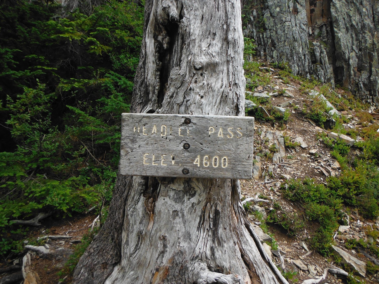
After climbing through the boulder field, the trail turns to the northwest towards Headlee Pass.  Really, the pass is a clef in the wall almost invisible until you start up it.  The first 100 yards is loose dirt and gravel.  Stay left and you might find it easier to make it to the switchbacks that wend steeply up the grade to the pass (4720'--though the old sign says 4600').  It was on this part of the trail I found a Swiss watch in the dirt.  I surmised the owner was pushing hard on the trekking pole on the arduous climb when the wrist band burst.  Anyway, any excuse to pause on that part of the trail was alright with me.  The watch had taken a lickin' and kept on tickin', a lesson for all of us on the Vesper Peak trail.  Eventually, we reached the pass. From the trailhead,  we had ascended 2370'.

After Headlee, the trail traverses through a great talus slide to more boulders that mark Vesper Creek.  Pause for a moment to admire the spires of Sperry Mountain above you.  They look like castle turrets.  Downhill, below the talus, a green valley opens up like a hidden Shangri-la.

At the creek, more cairns need to be followed. If you stay on the right side of the stream, you'll end up at Vesper Lake, an over-sized tarn of glacial melt water devoid of vegetation.

Ernie navigates the talus slope


Vesper Lake
For those who demand even more punishment, crossing the creek will lead you to the summit.
Briefly, the trail is visible then is obscured by the heath.   We wandered after an errant cairn and momentarily lost the way, but regained the trail quickly.  It stays left of the ridge line above the lake, and climbs sharply through the heather for perhaps a quarter mile.  Here we interrupted a marmot having an early lunch. 

Once through the heath and stunted spruce, you'll step out to an open granite slope below the summit block.  The final challenge of hopping boulders and scrambling up a tilted table top of granite begins. Cairns lead the way up, and we could see Brad's party already on top.  After stashing our trekking poles we began the scramble.  For the most part, the going was steep but rarely required hands.  
Brad's Friends waiting for him on top of mountain.
About half way through this portion, we were overtaken by a young man named Dylan who seemed to ascend nonchalantly past us. After maybe twenty minutes of heart pounding work, we made it to the summit where we found Brad's friends just finishing their lunch.  The watch was reunited with one of the party, a guy named Pete, who was disappointed we didn't recover the pin that holds the broken band to the watch.  Ernie and I caught our breath and drank in the views.
Vesper Peak

Copper Lake


The Glacier

Dylan, a 27 year old who had just finished a Masters in Microbiology, had been there maybe five minutes in advance of us.   We all ate our sandwiches together and had a great conversation about education, archaea, and switchgrass as a source for bio-fuel.  For me, the people I meet along the trail are often times as interesting as the scenery.  
The overcast was breaking up a bit and some blue sky was peaking through.  It wasn't a perfect vista, but it was rewarding.  The Vesper Glacier, Copper Lake, and Morning Star were all visible.  Glacier Peak and the other great monarchs of the Cascades were still veiled.   As we got ready to head down, Ernie remarked it would be nice to come back on a clear day.
We follow Dylan off the summit.
The trail out, given its various challenges, is nearly as difficult as coming up.  Certainly, the pressure on the knees is more acute.  For a short while, we kept up with Dylan, but it didn't take long for our creaking joints to slow us down.  Plus, I lost my hat, and had to re-climb a stretch of a few hundred yards to reclaim it.  When I got back down to Ernie, the kid was long gone.
It probably took us over two hours to pick our way back to traihead.  Gravity worked with our cardio but against our menisci.  Ernie took a couple of Advil along the way down, and we stopped at a stream and drank some cool, purified water which made the tired journey out a little more bearable.  All in all, Vesper Peak is a very challenging day hike, but worthwhile.

Here's the WTA Vesper Lake link for directions: 

Tip on the directions:
If you plan on hiking Vesper Lake or the peak, reset your car odometer at Granite Falls.  Look earnestly for the road to the trailhead after 28 miles.  The sign for the turn off is obscured by brush and easy to miss coming from the west.   

The classic guide book:  
*Spring, Ira and Manning, Harvey.  100 Hikes in Washington's Glacier Peak Region,                                         Seattle: The Mountaineers, 2003.

Tuesday, July 21, 2015

Mt. Townsend: A view from crags to sea


     If you are looking for a great day hike with a different feel and look compared to the typical central Cascade trek, beautiful Mt. Townsend, on the west side of Puget Sound, offers a wonderful alternative.   Mt. Townsend,  named for explorer George Vancouver's friend, Marquess Townshend*, is a popular 6200' bookend to Mt. Pilchuck on the other side of the Sound.  Both have significant prominence as the first real mountains off the shores of Puget Sound.  Both are lovely hikes that move from old growth forest to a summit above a treeline with views of nearby peaks all the way to the water.   Townsend, however, belongs to a different geology and the  more ancient range, the Olympic Mountains.  In addition to hemlock, fir, and spruce that you will find on both hikes, on the lower third of the Mt. Townsend, grand  rhododendrons tangle up.  Higher on the mountain, scrub pine twists in to krummholz or elfin trees.  As one of my hiking buddies, Ernie, put it, the place just has a different green.  Finally, while both Pilchuck and Townsend have water views, because of its location, Townsend's vista seems to encompass almost all of Puget Sound.

  The many perks of the hike makes it popular if not easy to get to.  From the Seattle and neighborhoods east of Puget Sound, the journey begins with ride on a ferry.  For us, it was the 7:55 AM Edmonds-Kingston sail. We walked on, but I paid a pirate's rate of $15 to park in a lot across from the dock. Ernie parked where he could and was fortunate not to be towed.  In retrospect, taking the Sounder Train would have worked better for me since it offers free parking and an easy way to avoid traffic snarls to and from the ferry terminal.

After the half-hour sail, Ernie's friend, Enrique met us at the Kingston dock.   From there we headed down Hwy 101 through a rock quarry and onto Forest Service Roads.  Enrique told me he taught Physics at the local high school,  but by the way he handled the twisting track in his Eurovan, I suspect he might also be amateur rally driver.   Despite the roller coaster ride of sometimes one lane roads, I counted five vehicles already parked at the trailhead when we arrived about one hour & 45 minutes later.  Please use the WTA directions linked at the bottom of the page.  I tried Google Maps, and the route that popped up was an torturous additional hour to another trailhead.  There are four starting points up Mt. Townsend.  From Seattle, #839 is the easiest place to begin.
Despite the difficult journey to the trailhead, it was, in fact, a perfect day for hiking.  The trail (#839) parallels Townsend Creek for awhile, and gets a lot of elevation early.  I belong to the "let's-get-it-over-with" camp, so I was pleased to knock out the UPs early.  If you prefer to build to a crescendo, you'll be annoyed by the early ascent.  The rhododendrons had bloomed much earlier in the season, so the soft forest trail was more like the nave of a great cathedral between holidays, sublime but not overly adorned. Six weeks earlier and we would have been in the midst of our state flower's blooming glory.   After about mile and half though the woods, the route takes you through meadow where a number of flowers where still blooming.  The trail is well-signed, but the way to the top stays right at Windy Camp, about 2.5 up the trail.
6200' Summit of Mt. Townsend
Just below below Windy Camp, in the open, but steep meadow, we ran into Dr. Mark, a retired General Practitioner.  It was somewhat serendipitous since we were having a discussion about various approaches to health care and their relative effectiveness.  Dr. Mark was catching and releasing bugs. The current state of health care helped push him into retirement.  Entomology is his new passion. Interestingly,  he is a disciple of Dr. Dennis Paulsen, the local bug expert, I had met once in Magnuson Park chasing dragonflies.  We talked briefly with Dr. Mark of health and diet. He advocated walking, red wine and chocolate. We also spoke of butterflies and deerflies.  Dr. Mark reminded us that you cannot keep the bugs you catch in a wilderness area.     I added,  "And you're only allowed to eat them accidentally."


Once at Windy Pass, the trail follows the ridge line up to a subtle summit.  The ambiguity of the high point here is probably a good thing since it diffuses the crowd somewhat.  The actual high point is located in what almost appears to be a man-made pile of rocks.   On top of Mt. Townsend, we were  treated to views of rocky crags, hazy distant monarchs of Rainier, Glacier Peak and Baker, and the sea.    The day of our hike, a cooling breeze scattered any menacing flies.   However, we were harassed by an angry chipmunk as we ate our lunch.   If you want to explore further, the north summit runs about a half mile away.  We, unfortunately, had a ferry to catch at 4 pm. 
View of North Summit
On the way down, I took some time to photograph flora and fauna.  More groups were struggling in the heat of the day, up the trail.  Always good to get an early start.  Further down, we ran into Dr. Mark again.  He had had a good day "bugging," finding a bluish butterfly and some red-eye winged insect with a scientific name of "e pluribus . . ." ( Sorry, I am a little rusty on my Latin).

Back at the trailhead, we agreed, Mt. Townsend has to be one of the most picturesque day hikes in the region.   For me it's in the running for one of my favorite day hikes of the summer.  With Enrique's driving, we made the 4 o'clock ferry with three minutes to spare.

Notes:
* Marquess Townshend was the brother of Charles Townshend, whose tax on tea started a little rebellion.  Overtime, the spelling was Americanized.  It's ironic that Townshend lends his name to one of the most patchouli-scented refuges for aging hippies in the region, Port Townsend

WTA Website: http://www.wta.org/go-hiking/hikes/mount-townsend

Hiking With My Brother Website: http://www.hikingwithmybrother.com/2013/08/mount-townsend-trail-839.html

Saturday, July 11, 2015

Green Mountain: Beauty & Biting Flies

Recently reopened after an 11 year closure,
 Green Mountain outside of Darrington is a beautiful and verdant hike.  It offers sublime vistas from a historic lookout and beautiful wildflowers to provide some diversion from the steep climb to the top.

The hike begins right off of Forest Service (FS) Road 2680, which is 19 miles of mostly gravel from the Hwy 530 via FS Road 26.  As of the summer of 2015, most passenger cars shouldn't have a problem with the surface, but always check with the ranger station.  My altimeter read just under 3500 feet at the trailhead, and the summit is listed at 6500.  With some simple math, the fours miles of trail climb about 3100 feet, but it plays longer. Just before the last mile or so to the summit, the path drops at least 100 feet to a couple of spring-fed tarns.  While the change in pitch might be appreciated, the elevation debt will need to be made up.  After the spring, a few long, aggressive switchbacks through open mountain meadow takes you to the top.

The trail is in good shape, and suitable for hiking shoes or sandals.  Heavy boots weren't needed when we hiked the trail.  Once you leave the forest, the brush and fern edge over the path.  As a mid-50s hiker, who likes the knee-cushioning benefit of poles, I found the overgrowth along the trail made it too narrow in places to use them.

The bugs arrived early to Green Mountain.  When I hiked Green Mountain with my friend, Ernie, in the second week of July, we ran into an Egyptian plague of flies.  Barely noticeable through the first mile or so as we hiked through the woods, the bugs became an increasing nuisance as we ascended into dense meadow of fern and wildflowers below the springs.

At the springs and above, the flies became a pestilence.  Perhaps a few hundred meters from the top, we saw a strange apparition hiking towards us.  Coming down off the summit of Green Mountain seem to be a bee keeper in a netted hood, but it was in fact only "Pink Sushi," the intrepid Cascade hiker who proved better prepared than Ernie or I. The deerflies and blackflies were out in force on a warm and hazy 9th of July.  Pink keeps careful records of such things, and he said he thought the flies on Green Mountain were clouding at least two weeks early this year. Typically, they don't achieve this level of nastiness until later in July.  Moreover, by Mid-August they will have had their fill of human blood, and begin to wane.  Little consolation that served on the 9th.  We suffered through bite after bite on the lush and verdant hillside.  To make matters worst, we hoped the restored lookout my provide some shelter from the attack.  Instead it was padlocked.  If anything, the flies owned the summit more than the meadow.

Glacier Peak through the Haze

We didn't stay long on top.  The flies were relentless, and some British boys were chanting about a ritualistic killing of a pig--no, sorry, see my South Pacific blog.   The early fires created an opaque filter to our panoramic views.  Even Glacier Peak, though nearby, was almost mirage-like in such conditions. In compensation, a riot of wildflowers was blooming along the way.
A few lupines, a pallet of Indian Paintbrush, a chorus of harebells, penstemons, and even the Dr. Seuss' favorite, Old Man of the Mountain provided moments of diversion from the pain and inching.

Another older hiker, working his way up the hill as we hiked down, pointed out to us that bug juice won't stop the ravenous deerfly, only long sleeve shirts and pants offered any protection.  It was too hot for that.  Mercifully, the trail is fast going down hill, and the flies couldn't keep up.  We made it to Ernie's SUV in good time, killing one or two flies that followed us into the car.  We both agreed Green Mountain is a beautiful hike, worthy of a return trip, after the flies are gone.
A glimpse of the Restored 1933 Lookout


Accurate directions for the hike can be found here on the Washington Trail Association website:
http://www.wta.org/go-hiking/hikes/green-mountain

Information about the road reopening can be found here:
http://www.heraldnet.com/article/20141023/NEWS01/141029578

Tuesday, July 7, 2015

Getting Past the Snoqualmie Pass Crowds

View of Rattlesnake Lake from the ledge

On a recent morning hike with my hiking buddy Gary up Rattlesnake Ledge, we encountered a phenomenon I had previously only heard about but never experienced--the stereophonic day-tripper.  A thumping bass could be heard around the next switchback.  As we approached, we discovered a jolly band of twenty-somethings struggling up the hill.  The alpha dawg had small but powerful speakers attached to his rucksack.  Apparently, our new urban hikers come complete with their own sound track they feel compelled to share with the rest of the world.    The dance music, in the right context, might have been fun, but on the trail it was an annoyance.  Luckily for us, the self-appointed MC of the trek and his posse were not in the best shape, so we were soon able to leave the noise behind.  However,  on the short but popular trail we caught up with another boogie monster within ten minutes.    As we passed this dude, too,  I wondered why he didn't use earbuds.  New metal doesn't seem compatible with the atmosphere.   Personally, I would rather hear the birds, the wind, or, of course, another one of Gary's lectures on the various geologic phenomenon we encounter along the way than screaming angst from der fatherland.

The popularity of hiking has increased tremendously in last several years.  Simultaneously, Seattle's booming economy is drawing more people to the Puget Sound region--sort of like a black hole sucking in galaxies. The Rainier factor brings out the nature lover in the legions of the new comers. Whether they hail from flat and bug infested lands east of Montana or writhing freeways of SoCal, not long after they arrive, many of the transplants discover nature.  Of course, this means that the once lonesome trails turn into Disneyland lines, particularly on the weekends along the I-90 corridor. To be honest with you, it has dampened my former missionary zeal for hiking.  Now I am inclined to a quieter Zen approach.  Like a savvy traveler, I don't want my favorite destination ruined by popularity.

It is absolutely the true that popularity has its price.  Litter and trampling of meadows have grown more common.  Feeding of wildlife, noise and just generally bad trail manners all are coming to your favorite hike. What can be done?  On an individual level, we can adjust when and where we hike.  A lot of my friends won't hike on the weekend, especially around Snoqualmie Pass.  They leave early midweek in an attempt to find solitude.   If they do hike on a weekend, they head to the Olympics or North Cascades.   For folks working a traditional week, this can be difficult.  They must hike early, or backpack beyond the maddening crowds.

A pretty good day-hiking book by John Zilly, called, Beyond Mt. Si suggests hiking on less popular trails.  Ironically, since the book was published in 2003, most of the alternatives suggested have become too popular, too.  Blame social media.    It is easy for newcomers and neophytes to learn about hikes on their own.  In fact, the Washington Trail Association (WTA)  web page creates tremendous wear and tear on trails they want to protect.

In the old days, friends and hiking groups introduced folks to the outdoors.  In the process, they taught the hiking ethic.  Without a guide, it seems that new hikers are heading into the woods without a clue.  Not only is this potentially destructive, but it can dangerous.  I have been on some trails where I have come across hikers not carrying a ounce of water let alone the rest of the ten essentials.

As experienced hikers, we need to teach the ethic of leave no trace.  As the leader of a high school hiking club, I gently remind my students to pick up and pack out everything, even their orange peels and bread crusts.  One boy told me, as he peeled his orange, it will biodegrade . . . eventually.   I responded by suggesting that no one is interested in communing with old eggshells, apple cores, and orange peels from this season's hikers.  We want the next party to feel as if they are stopping in pristine wilderness.

Better signage at the trailheads could also help. Friendly, but pointed reminders, could teach different aspects of outdoor ethics and etiquette at different trailheads.  The "Leave No Trace" lesson at Rattlesnake might focus on turning off the music.  At Granite Mountain, it might emphasize not picking wild flowers.  In the Issaquah Alps, letting the gray jays feed off of deer ticks instead of your trail mix would be beneficial to trail travelers and feathered friends alike.

Finally, we need to build more trails to keep up with the growth of the population and the interest in the outdoors.  Alternate routes to lakes and summits could diffuse hikers and create greater solitude.  New trails to new destinations could be blazed.  Working with the State and Forest Service, the WTA, Mountaineers, or Scouts, could provide a real service by increasing the miles of trails available.  The rest of us can contribute money, time, or both to make it sure happen.

Thursday, August 14, 2014

White Chuck Mountain: Remote Beauty and Danger

Outside of Darrington, Washington, spires of beautiful peaks needle the sky.  Sloan and Pugh are sublime.  White Horse and Three Fingers are mantled in glimmering glaciers.  Among all of these impressive peaks sits a homely neighbor, White Chuck Mountain, a block of fracturing rock.  In geologic terms, it is dissolving in the mists and winds of the Cascades.  To us, with our relative, mayfly-flash of existence, White Chuck Mountain is an isolated monument robed (as the old hymn celebrated) in colors of blooming spring.  Certainly, for the adventurous, the mountain possesses intrigue.  From its slopes, amazing vistas open up.  The climb up bootpaths and goat trails cross exposed and slippery sections of rock.  Talus slides offer a fast exit to oblivion for the careless or unprepared.  Given its isolation and danger, a trip out to White Chuck Mountain will likely offer more solitude than any other of the alpine scrambles in the Central Cascades.  For the technically-skilled scrambler, intent on a quick peak to bag, or the cautious hiker who can be happy turning back before the summit, a half-day on White Chuck Mountain can offer a beautiful challenge.

Mt. Baker to the north
Mt. Pugh and Mt. Sloan
Getting There.  Begin traveling I-5 North from Seattle to the Arlington, Exit 208.  Take 530 East past the tragic Oso slide towards Darrington.  At Darrington, turn north.  Just before the Ranger Station, take a right onto Sauk Prairie Road.  ~1.5 miles turn right onto Dan Creek FSR #24 and follow this for 8 miles keeping left at the fork at 4.3 miles. The road switchbacks several times then begins a long traverse into the head waters of Dan Creek.  After ~8 miles on FSR #24, the road reaches a T-intersection. Turn left onto FSR #2430.  Shortly thereafter stay right at a minor junction onto FSR #2435.  From here-on follow FSR #2435 for 5.3 miles as it winds it way into the headwaters of Decline Creek.  It eventually reaches the ridgecrest, switchbacks some more, and comes to a fork.  At this last fork, stay to the right and follow beyond an impressive, stomach churning "devil's dip" to the end of the road. This is where the trail starts, elevation 4800'.  (Directions courtesy of Summit Post) 

Logging Trucks!
If you are making a list of reasons not to hike White Chuck, add logging trucks.  The trailhead is near actively logged forests, and independent truckers barrel down the narrow Forest Service roads with dollar signs in their eyes.  When we went up in early August, we were lucky to avoid any stand-offs the Suburu would have lost.  However, due caution with eyes down the road, and a runoff plan in place are necessary when timber cruising in working forests. 
The Trailhead

The trailhead is really nothing more than the stub-end of a logging road.  We turned around to face down hill before even starting the hike.  Obviously, a place rarely visited will not have a privy.  Bring your own trowel, and follow responsible wilderness practices. If you're primarily interested in photography, Ansel Adams could have spent a roll of film just where the hike begins.  
Heath along the approach trail

The Trail to the foot of the Mountain.  At the uphill corner of the trailhead, the trail climbs the ridge to the southeast and carries you through brush that tangles up an area logged fairly recently.  Soon you will follows the ridgeline to the south for a mile and half.  Blowdowns present obstacles in a few places as this is not a trail the forest service cares to improve.  Why entice more hikers out on roads with logging trucks, to untrampled mountain meadows, and dangerous, scree-skidded slopes?  That being said, enough boots have trodden the path to make it easy to follow to the northwest base of the mountain.  When you hit the avalanche field at the foot of the Northwest Peak, the trail veers up towards a gully. 
A mountain meadow and a turn up the gully
(photo by L. Eickhoff)

The Risk Factor Increases.  As long as you are not allergic the ubiquitous bees bumbling from blossom to blossom, the first part of the hike is relatively easy and safe.  Once you get to the gully, however, the risk profile is altered, and you make your way up among the scree fractured from the rock cliffs above.  Ascend the gully carefully.  A few traces of trails head north out of the gully.


A Slip and a Reflection on My Life.  On our way up, we probably followed in the footsteps of others who followed the cloven trickery of a devious mountain goat.  A couple of turns took us across some shelves of rock that seemed too treacherously steep to be blazed by gentle hikers such as us.  Regardless, we ascended to the saddle between  the Northwest Peak and the summit block of White Chuck.  From there, we followed a trail that seemed to wend us out to the southwest.  Small cairns apparently guided the way.  At one point, I followed one across a broken talus field.  My  handholds disappeared.  Still a hundred feet from the next cairn, on a significant grade, I felt the scree slip beneath my feet.  30 or 40 feet below me, a cliff offered a fast trip off the mountain.  Unfortunately, at the bottom of the ride is an abrupt coming to terms with the physics of an object falling 1000 feet, 36 feet per second squared.  Gingerly, I turned back and told my hiking buddies this wasn't the way for us.  Perhaps light-footed elves or climbers with either protection or delusions of immortality could traverse this section, but not us.  Since it was getting late in the afternoon, we decided to head down rather than search for a less dangerous path to the mountain top.
Glacier on the northeast shoulder of White Chuck Mountain

We stopped at the saddle again, ate a snack, and took some pictures of the White Chuck Glacier, Mt. Baker, Mt. Pugh, and Mt. Sloan.  On the way down, we paid a little more attention to the lupine, columbine, and stonecrop in bloom.  Even a transient contemplation of mortality can help one's appreciation of beauty.

Vampires have nothing on these guys...  The way down along the lower trail to the car seemed humming with more mosquitoes, desperate to get one last bite of us before we left.  Of all the miles I tramped through the hills this summer, I encountered more bites per mile on the slopes of White Chuck Mountain.  Add bugs to your list of reasons to pick another hike.  The solitude of the place will last.
Pink violets

Smooth Douglasia

Bluebells

Indian Paint and avalanche lily

Yellow Stonecrop (photo by L. Eickhoff)
Lichen paints abstractions on the rock

Tuesday, July 22, 2014

The Oyster Dome: An All Seasons Hike


The Chuckanut Mountains are an ancient upwelling that shore up the Salish Sea just south of Bellingham. Washington.  Ancient and worn down, they predate their upstart and angry Cascade neighbors to the east by eons.  In the last ice age, some of the higher peaks of the Cascades asserted their prominence beyond the frozen sheet.  Alas, the Chuckanut Mountains slumbered beneath the deep and heavy winter.  Fortunately, for us modern folks, the ice receded and left us a few glacial polished high points worth a half day adventure anytime of year.  The Oyster Dome, on Blanchard Mountain,  is the most popular. At 2025 feet, the outcropping above the beach offers a unique vista from the San Juan Islands to Canada.  You can mark the slow progress of ships at sea while snacking on trailmix.  On our last trip up, two bald eagles put on an aerial display swooping and tumbling in the updrafts.

Close to the outdoorsy college town of Bellingham, the Oyster Dome trailhead is problematic. Year round, a lot of folks are eager to head up.  Unfortunately, there is no parking lot available on this side of the hill.  Cars must park on the shoulder of Chuckanut Drive, and it's been reported that  vehicles over the fog line have been towed.  The near-by Oyster Bar Restaurant is also off-limits, even for early morning trekkers.  The trails are on state lands, so a Discovery Pass is required.  However, a final, uncomfortable reality is the lack of a toilet.  Take care if you venture off trail to relieve yourself--the hill is steep.

Start early and you'll have a more pleasant start to the hike.  The first part of the trail is well maintain if a bit aggressive.  After all, the way ascends from a few hundred feet above the Salish Sea to just over 2,000 in a rapid three or so miles.  A few trail crossing can also be confusing. The Oysterdome Trail intersects with the Pacific Northwest Trail twice.  In each instance stay left as you make your way through a lowland forest of fir and hemlock.

The bat caves at the base of the rocks are closed now for fear of spreading white nose syndrome among the native bat species.  By June, the turn off sign had been removed.  After the old turn off point, the trail is ridiculously steep--really a scramble up 200 yards of roots and rocks.  Here, all hikers can benefit from trekking poles, on the way up, and especially on the descent.   At the top of the scramble, take the second left, across the creek, and you are a quarter mile from the through thin but dense second growth  to the top.  The other way leads to Lily Lake.

The Dome is a bit of a misnomer.  This is not an orb sculpted from granite, but rather a edge of a folded crust.  Still, it offers a stunning view of the Puget Sound.   Take care along the edge.  The exposure is real enough, 300 feet to the foot of the bat caves.  Thousands of  panoramics and selfies are snapped at the Oysterdome every year.  Don't be distracted by the view.

Even when its not a perfect day in July, the 1900 foot accent is worth the effort.  When we were there in late winter, the elevation was enough to put us in snow while the lowlands endured drizzle.  The snowfall has its own beauty but it obscures the point of the hike; we made our way down fairly quickly after the flurry began.

Our last trip in June, we made the side trip to Lily Lake where we enjoyed the wild irises among the pond lilies.  The work of beavers is evident everywhere making the short excursion a fun destination for kids. Fall spruce giants provide piers almost to the middle of the boggy lake.  A few minnows scattered from our shadows while dragonflies patrolled the above the water.

For the ambitious, other trails can lead to the other side of the mountain, Lost Lake Fragrance Lake, and even Lake Samish, but that would turn a half day adventure into a full one.

From Seattle, getting to the Oysterdome Trailhead is simple.  Head north 75 miles on I-5 for an hour and 15 minutes or so, then take Exit 231 to Chuckanut Drive (Hwy 11 north) on the west side of the freeway.  The trailhead is just past mile post 10 on the uphill (east) side of the road.  Be careful making the u-turn to face your car in the right direction--motorcyclist and BWM drivers love to ride the curvy road fast, and make sure you are completely off the road, so you don't end a great hike searching in vain for a towed  vehicle.


Tuesday, July 1, 2014

Beckler Peak's Fantastic Vistas


  The Forest Service Road (6066) to the Beckler Peak trailhead is rutted and rugged.  Chunks of granite brought in by the Forest Service to patch the holes sometimes rudely announced their resistance to traffic by thumping against the underside of the sedan I was riding in.  Clearance is everything on this road.  It's over six miles of single lane, slow going from Hwy 2 to the start of the trail. With reports of late winter blow downs blocking the road (though cleared some weeks earlier) and heavy snow on the trail (perhaps a bit overstated), the parking lot was almost empty--one other car when we arrived on the last morning of June.   Apparently, solitude here should be cherished--the new trail to Beckler Peak was only opened a few years ago, but the word has gotten out that the vistas are well worth the effort.


The trail to the summit is a bit more than 3 1/2 miles.  It begins on a converted longing road, at the edge of "working forest," but the cool shadow of hemlock disguise the fact well.  Lupine and tiger lilies adorn the trail.  When we were on the trail, the fireweed was a week or two from blooming into profusion.  The way up the first part is un-apologetically steep. Our minds were distracted by discussions of botany and potential herbal remedies, but our calves were not.  The ascent can get your heart pumping to a beat your feet can't keep pace with.  Fortunately, the road relinquishes the way to a carpet-like trail that sashays towards the west and ridge where the Beckler finally made his point at 5062 feet.

We encountered patches of snow, four feet deep in places, but trail was well trampled.  Like many middle-aged hikers, I am a convert to trekking poles.  On snow, they help you keep your footing and spread the load a bit.  If you should post hole down, poles can keep you from twisting a knee or breaking an ankle.  They also help you burn a few more calories as your arms become more involved in your life.  For me the biggest pay off is the stress they take off the knees especially on the down hill.


Once you're in the second growth forest below the summit, the incline has been nicely mitigated by a few strategic switchbacks.  Well placed rock steps keep the trail from spreading into a quagmire during the melt out.  After nearly two hours of work, summit came suddenly.  It seemed as if we were in the rocks and spruce one moment, and in the next, on top of the world. Leonardo diCaprio, however, was no where to be seen.  Mind your step when you reach the top.  Between you and Glacier Peak to the north is a unbridgeable chasm.  The views here are 180° of peaks,  valleys and the little of town of Skykomish clinging to its namesake river.

Beckler Peak compares favorably to other vista hikes in the Central Cascades.  It is a little stepper and longer than Mt. Pilchuck, but the trail is nicer, and there are far fewer people on a weekday.  On Beckler, we met a retired couple coming down the hill.  After spending a hour or so on top, we headed down, and met a couple of college kids heading up.  A half day on the trail, and we encountered a total of four people.   Compared to last week's hike on Pilchuck, on a misty day, when we crossed paths with scores of other hikers, this was solitude.

Mt. Pilchuck is a favorite hike of mine.  Coming from Snohomish, it's easy to get to.  It also has an historic lookout and plenty of room for everyone at the summit.  Beckler, on the other hand, has no look out, and only room for six or eight hikers on top.  That being said, the view from Beckler is unrivaled. It is definitely worth the effort.

To get to the Beckler Peak Trailhead, take Hwy 2 East (about an hour out of Everett).  Approximately, two miles past the Skykomish Ranger Station, you'll see the sign for FR 6066 on the left.  It is an abrupt turn off the highway, so use caution.  Stay right at the Y 1.8 miles up the road, and head up hill.  The trailhead is just under 4 miles of rough road away.  Unless you are in a Range Rover, it will take at least a half-an-hour of dodging and weaving potholes and rocks to get there.  On the day we were there, much to the irritation of the ladies,  the privy was inexplicably locked the entire time


.