Friday, June 24, 2016

The Throngs on Mt. Pilchuck (Tips for New Hikers)


Mt. Pilchuck snowcapped in Spring
Pilchuck in Autumn
Snohomish country's favorite little day hike has to be Mt. Pilchuck, off the Mountain Loop Highway. The three-mile hike to the top gains about 2,300 feet of elevation, and provides a little alpine experience close to home. Pilchuck stands out for miles along the I-5 corridor, north of Lynnwood past Marysville, so once you've hiked it, looking east can provide a momentary escape to a great day on the trails. This is especially nice if you're stuck in traffic in the notorious Sno-King squeeze.

To get to the trailhead, take the Mountain Loop Highway ten miles out of Granite Falls.  The turn off to the seven mile access road is just past the bridge, on the right side of the road,  less than a mile past the Verlot Ranger Station. Stop in Verlot if you need to renew your Northwest Forest pass.

The road to the trailhead can be a washboard mess though the last couple of summers, it's been pretty good. Your mother's Buick could have taken us to the parking lot when we headed up at the end of June 2015.  This year, there were some potholes that might swallow a Smartcar, though a school bus made the trek.

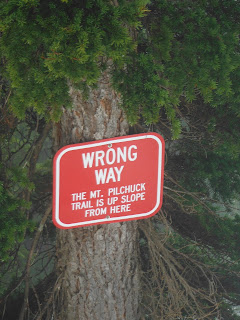
There's a privy at the trailhead, but no guarantee it'll be stocked with TP.  Register your party a hundred yards up the trail.  Causal hikers will be amused by the warning sign ignored by many.

The trail goes up right away, first climbing a forested ridge, crossing a rocky avalanche field, then turning out of the woods for great views of Three Fingers.  Above the heavy forest, you'll edge into the open old ski bowl and cross through the big chair remains.  Your trip to the summit will be a little more work than those early skiers taking on the Cascade Crud of the 1960s.    The trail in winter goes almost straight up.  As the snow melts out, it switches back to the north where it ascends the summit block.  A couple more rock slides and a bonsai spruce forest open up to the historic look out on the summit.
To access the look out requires a little bit of scrambling over boulders and a climb up a short ladder. This can prove to be a challenge if you are hiking with small children or dogs.  Once you reach the look out, you'll enjoy panoramic views with plaques to help identify distant peaks and little history of the place.
The Look Out Approached from the Snow Route
Pilchuck's visibility means the trails get a lot of traffic. Yesterday, we counted well over a hundred hikers trudging along including a grammar school group, and an entire high school football team. Throngs are attracted to the mountain because it offers natural beauty, history, and wonderful views from the top.  Facebook and Instagram sell the hike better than guidebooks ever could.
Instagram Beauty from the top
 Unfortunately, the proliferation of outdoor enthusiasts also means more wear and tear on the trails in a time of shrinking budgets. It also means a lot of neophytes enter the forests unprepared and unaware of dangers. They lack the equipment, fitness level, and ethos to ensure their day in the woods will be great for themselves and everyone concerned.  Some end up hurting themselves.  Many other are hurting the mountain and ruining the experience for others.


The number of the inexperienced people we saw on the trail yesterday probably out numbered old sourdoughs ten to one,  One group of twenty-somethings only had a 12 oz sports drink bottle to share with each other. It was empty by the time they got to the top. On a mild and partly cloudy day, they were only a little thirsty. When I asked if they wanted some water, they said,  "No, we drank from a little stream that crosses the trail."

I warned them about giardia.  They didn't believe me,  "Is that a thing?"  A microscopic, cysty-thing.   They appeared young and fit, wearing only workout clothes and running shoes. One of boys told me that they came up last year and it was really slippery. Naturally, they didn't pack a warm jacket, rain gear, or even a granola bar. None carried a knapsack. I am certain they got back to the parking lot fine. Time will tell if giardia will strike.

From late October or November, through May and even June, Mt. Pilchuck can be snow capped. After all, it used to be a ski area. As late as early July, it can make an adventurous day hike that takes you from the shadowed forest across rocky avalanche fields, and through several feet of snow to the historic look-out on top. A few weeks later, after all the snow is melted from the trail, the climb to the summit can be knocked out by the super-fit in less than an hour. For the rest of us, in mid-summer form, it can be crowned in under two hours.
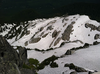
Snow in early July of 2013 started a mile past the parking lot.
Snow in late June of 2016 at 5080 ' 

For such an accessible and fun hike, Mt. Pilchuck has seen its share of tragedy. A yoga pose on a summit rock can go wrong.  Losing the trail in snow.  Messing around along the ridge.  All can result in deadly tests of gravity.   A year ago, when we got to the trailhead, a county deputy was standing by a Search & Rescue rig.  We feared the mountain had taken another life.  Apparently, a couple started up late and got caught in a frightening storm that brought the temperatures down to an unpleasant 40 some degrees.  In the cloud cover the total darkness can be unnerving when you aren't positive where the trail is located.  Cliffs bracket the upper reaches of the hill.   The couple hunkered down in the look out and called for a helicopter rescue.   They were told to sit tight until morning. They weren't injured, and it certainly wasn't flying weather.  Undoubtedly, they spent an unpleasant night on the mountain, but they made it out okay, if not somewhat ungraciously.

The ill-prepared couple were also surprised to find out the historic look out didn't come with a heater. We know this because they wrote angry graffiti on the walls.  When we arrived just after Search and Rescue got to them in the morning, smoke lingered from their attempt to warm themselves by a fire. This was problematic since the look out doesn't have chimney.  They're lucky they didn't asphyxiate themselves or burn down the beloved fire look out.
It turns out this is only angry graffiti and not
the last will and testament of the ill-prepared couple


This might be an appropriate time to think about trip planning and the ten essentials.  Here's a list from The Mountaineers:
            Courtesy of the The Moutaineers, 
 A headlamp with a fully charged battery is part of your essential gear. This might have helped the "helicopter rescue couple,"  On two long day hikes, in last few years, I have had to use my headlamp for the last mile or two.  I didn't expect to need it, but we were slowed down by situations beyond my control (see my blog on Three Fingers).   In a dense forest, sunset comes early, and the night is far darker than you might expect.

A warm jacket to put on when you stop prevents discomfort at cooler elevations, it might also prevent hypothermia.  No need to start a fire in a treasured landmark.   Clean and safe water will make even a short hike more pleasant.  If you are hiking with kids, stop and drink water on the way up.  Don't drink from streams or lakes without filtration.  In July and August, you can suffer from heat stroke even on the west side of the Cascades.
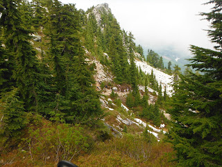
The football team momentarily on the trail
The ten essentials doesn't include a hiker's ethical code, but it can be summed up with, "leave no trace."  On our way up this week, we watched a number of the football team cut switch backs, and head straight up the mountain.  When I told them that it wrecked the hill, they were polite but dismissive.  For them, it was a race to top no matter what the cost to the fragile alpine ecosystem.

I was proud of my normally mild-manner friend, Warren, who called out a crew of twenty-somethings cutting the Lake 22 trail earlier this month.  It's one thing to be 16 year-old boy trying to prove you're the top dog.  By 26, you really should know better.  Trail cutting demonstrates not only a selfish disregard for nature and others, but a complete lack of imagination to think that you're the only git to go bushwacking and to not comprehend the impact of a thousand gits every summer doing the same thing.
Ditto for speakers on your pack.  I love music, but in the woods, I want to hear birds, wind, and perhaps the growl of a black bear.  I don't want to hear your German metal or latest hiphop dance beats.  If the solitude frightens you, and you need the comfort of an urban lullaby, wear headphones.

Mt. Pilchuck is an awesome hike.  It's no wonder the maddening crowds throng in.  With a little consideration for others, and a bit of preparation we can all have a safe and enjoyable time on the mountain.



Tuesday, June 21, 2016

Best Short Hikes in Lords Hill Regional Park (Snohomish County) #1 Temple Pond via Red Barn Trail

Lords Hill Regional Park, on the backroad between Snohomish and Monroe, has a lot to offer local hikers, trail runners, equestrians, and mountain bikers.  It is a lovely preserve, over 1,400 acres, available in all seasons, and it doesn't require a long trip into the mountains to get to, or even a pass.  The trails are family-friendly, but  parents should provide their kids with a brief lesson about the nasty nature of stinging nettles and devil's club that are prolific in the lowland forests of the Pacific Northwest.

As a local supporter of the park, I was disappointed to read mediocre trail reports of Lords Hill.  After all, it's hard to match the experience this close to the city.  It is a multi-use park, so you do have to be wary of loud and fast mountain bikers clattering down the Pipeline, and minefields of horse pucky left behind by friendly equestrians.  However, with a little more local knowledge, a few hours ranging the trails of Lords Hill can be quite enjoyable.

The problem is most folks lack information to have a great day at the park.  I'll be the first to admit that maps and signage in the park might earn a C if you're an easy graders.  Moreover, writers meeting deadlines do a cursory job of researching the park.  They tend to revisit the most popular destination (Temple Pond via the Main Trail) and call it good.  Undoubtedly,  Temple Pond deserves the attention--it is a lovely Zen place, rain or shine, in any season.  However, if the journey is as important as the destination, then I would recommend an alternate route to achieve tranquility.

The Main Trail is a really a compacted,  rocky old logging road, hard on the knees and ankles.  On a nice weekends, it gets a lot of traffic. Besides hikers, mountain biker, and middle aged women on horseback, on three different occasions,  I've even encountered an ancient couple driving down the road in their Chey LUV circa 1980 apparently taking a short cut around the traffic barriers, down to Monroe.

Interestingly enough, the best route to the lake is not on the park map.  It's called the Red Barn Trail. While a little longer,  the Red Barn Trail is less traveled and still in good shape.  As a bonus, it skirts the outer edge of the Beaver Ponds and brings you to the backside of the Temple Pond.

Stinging Nettle (Urtica dioica)
 Maybe you shouldn't have worn shorts.
Like many wet places in the Northwest, the Red Barn trail has its share of nettles.  If you are hiking with kids, teach them about stinging nettles.  They line the trail in a number of places, and can turn a fun walk in the woods into a crying fest.  As the poet Denise Levertov pointed out in a line of her poetry, (The Rebuff), the stinging nettle has "no spikes, or thorn, . . . nothing like that to warn the hand."  It does have soft, small hairs on the underside of the leaf, ready to burn the unsuspecting.

To find the Red Barn Trail, start the day at the main trailhead (12921 150th Street SE Snohomish).  As you head down the trail, stay left at the first major T, perhaps a quarter mile from the trailhead.  The sign will point to the Beaver Lake Trail.


The trail you want begins left (north) of the Beaver Lake (ponds).  The start of the Red Barn Trail is signed once you're on it, north of the ponds.  Beaver Lake?  Even in the height of a wet winter, the ponds look more like a big marsh with sentinels of cattails standing watch.  Listen for the fluted call of the red-wing blackbird, a favorite visitor to the wetlands.

The Red Barn Trail arcs up the hill above the ponds, then banks back down.  The name-sake barn is visible from the high point, and I suspect, respect for the property owners has kept the trail off the official park map.  A great photo opt can be found at the far end of the pond, looking back.

After the trail leaves the pond, it heads east up a small ridge then through a seasonal creek the south towards Temple Pond.

When you come to English Pond Trail sign,  continue on Red Barn and make a fishhook to the three-way junction of English Pond Trail, Temple Pond Loop, and Red Barn.  These mark the end of the Red Barn trail.   You can save five minutes, and take a shortcut to end of Red Barn by turning right onto English pond trail,

At the junction of the three trails, head south towards Temple Pond, by hanging a left.  The loop trail doesn't actually take you to the end of the pond.  It loops back about half way down.  However, if you feel adventurous, you can follow another unnamed trail that follows the shoreline south, then hops over a small creek, and eventually, connects to the Temple Pond View trail on the other side of the pond.  This will allow you to circle the pond, more or less.

The best view point is off the Pipeline Cutoff Trail.  To get there from the Temple Pond View trail, take a right UP the Pipeline Trail.  A steep climb of a 100 yards or so will bring by a memorial statue and bench on the left side of the trail.   Just past this, you'll find the Pipeline Cut Off trail.

Note:  the Pipeline is the Spine of the park.  If you become disoriented, find the Pipeline Trail.  If you parked in the main parking lot, head uphill (West) to Beaver Lake Trail, then take a left.   When you reach Board Walks, take a right to the trailhead.

Another 100 yards or so down the Pipeline Cutoff, look to the left for the trail to the viewpoint.  Get ready of this: it is UNMARKED.  Follow the viewpoint trail to an open ridge with a good view looking South.  Given the elevation, the viewpoint is fairly unrestricted.

To finish the day, return to the Cutoff trail.  Heading left will bring you to the junction of the Main Trail,  Take a right onto the Main Trail, and stay on the old logging road past the other Cutoff and the Equestrian entrance. Take a left at the Board Walks, and you'll be back at the trailhead in no time.

Walking along the Main Trail will prove my point about the park.  Most of the traffic, people, horses, and mountain bikes, all make their way down the rocky main trail.  I think you'll be happy with your decision to have started on the less-traveled trail when you began your little excursion in Lords Hill Park.

Obviously, this hand drawn map is not to scale  and is only meant to show the 
relative location of the Red Barn Trail to other trails and land marks in the park. 
Use the official map to assure accuracy.  It can be found here: